Friday, October 14, 2011

Photos of Utah's National and State Parks


Many of the visitors to this site are attracted by the photos of Utah's spectacular parks. The following slide presentation puts a few together for your enjoyment of Bryce Canyon, Capitol Reef National Park, Zion National Park, Glen Canyon National Recreation Area and Dead Horse Point State Park.


Check out Canyon Country Jigsaw Puzzles.

Friday, October 7, 2011

Hike the Trails in Canyonlands National Park , Utah, Using a Great Map


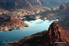
To get the most enjoyment out of hiking in Canyonlands National Park, southern Utah, you need a good map. Check out this one, Canyonlands National Park-Needles/Isle, UT - Trails Illustrated Map # 210 [Folded Map] from National Geographic.

Click on the ad for more information.


Product Description
This map is updated to reflect road closings, new trails, and campground relocation, and includes detailed trail information, points of interest, trailheads, picnic areas, facitlities, and more.

Included on the map are Canyonlands National Park, the Island in the Sky district, the Needles district, and the Maze district. The map also includes the Colorado River, the Green River, Indian Creek Wilderness, Bridger Jack Mesa Wilderness, Butler Wash Wilderness, Canyon Rims Recreation Area, and fascinating information about the park's archaeology. Ideal for recreation activities in this beautiful area, including hiking, biking, camping, climbing, photography--any back-country outdoor activity. Includes UTM grids for use with your GPS unit.

Scale = 1:70,000 Size: 26'' x 38''

About the Author
Founded in 1915 as the Cartographic Group, the first division of the National Geographic Society, National Geographic Maps has been responsible for illustrating the world around us through the art and science of mapmaking.

Today, National Geographic Maps continues this mission by creating the world's best wall maps, recreation maps, atlases, and globes which inspire people to care about and explore their world. All proceeds from the sale of National Geographic maps go to support the Society's non-profit mission to increase global understanding and promote conservation of our planet through exploration, research, and education.

Saturday, September 3, 2011

Lake Powell Has the Seal of Approval


Lake Powell, in Glen Canyon National Recreation Area, has got the "Seal of Approval"! However, you do have to use your imagination a bit.

At Wahweap, I managed to take two boat trips on Lake Powell, exploring the canyons, visiting Rainbow Bridge and cruising around this vast and magnificent lake. Perhaps the attraction isn't so much Lake Powell itself but the rock formations around the edge.


This particular rock formation is really only visible from water level whereas many of the others are more obvious from the air when gaining a bird's eye view.

You will have to zoom in on the photo to enlarge the "seal" on the right hand side of the picture just above the water's edge.


Cruising on Lake Powell and manoeuvring through the canyons is one activity you have to put on your list of "must do" tours. The boat captains are very skilled and well versed in the history, culture and geology of their patch. They also have a great imagination, a wicked sense of humour and an eye for the unique beauty of the area.

Looking up at these great hunks of rock really brings home the fact that we're just tiny specks compared to the vastness of nature. Quite a humbling experience.

Here's more information on Glen Canyon National Recreation Area.

Thursday, August 4, 2011

A Compact Compass Gives Confidence in the Canyonlands


A good magnetic compass in the pocket, hiking backpack or around the neck is always a great backup to have when out walking. I like to wear mine dangling around the neck because I always know where it is and it's easily accessible. Here's one to check out: Suunto M-3DL Compass.

Click on the ad for more information.


Product Description
Hailing from Suunto's M-Series, the M-3DL is a compact, premium-quality precision compass designed for accurate and convenient direction taking. The user-friendly compass features a large, liquid-filled capsule and an adjustable declination correction scale that guarantees a high level of accuracy. Another convenient feature is the serrated bezel ring, which is easy to turn even in cold conditions while wearing gloves. And thanks to the easy-to-read luminous markings and magnifying lens, the M-3DL is ideally suited to navigating in poor visibility. The compass even features a base plate with anti-slip rubber pads for stability and rounded edges for ergonomic comfort in the hand.

The M-3DL employs Suunto's two-zone system to help adventurers find their way anywhere in the northern hemisphere. Previously, most compasses functioned well in only one of five geographic zones. That's because the compasses were balanced differently based on the zone's inclination, i.e., the vertical intensity and direction of the Earth's magnetic field. However, as people began to travel more, it became clear that globe-hoppers needed compasses with a greater geographical range. Suunto's two-zone system, by contrast, considers only the northern and southern hemispheres. In practice, this means that a Suunto compass designed for the northern hemisphere--as the M-3DL is--will still work for a fair distance into the southern hemisphere and vice-versa. Suunto is one of only two compass manufacturers to offer two-zone compasses.

The M-3DL, which also features a jewel bearing and marking holes for drawing control points, measures 2.4 by 4.9 inches and weighs a mere 1.6 ounces. In addition, the compass carries a lifetime warranty.

Tuesday, August 2, 2011

Capitol Reef is Captivating, Really


Capitol Reef National Park, one of the Utah parks in the south, really is captivating. It's a long skinny national park accessible between Torrey and Hanksville. Or if you're doing a clockwise trip around the national parks like I did, it's between Bryce Canyon National Park to the west and Canyonlands National Park and Arches National Park to the east.


I love photographing different signs. The national parks, in particular, have a clear welcoming sign that lets you know that you're in for something spectacular. Photographing signs also indicates where the next photographs have been taken. It's also not a bad idea to photograph the sign when you leave a place (for obvious reasons).


The Visitor Center very fittingly blends in well with its surroundings. It's well worth a visit to pick up maps and information, look at the exhibits, watch a short video, buy souvenirs and use the rest rooms. The location is at the junction of the Scenic Drive and Route 24.

I really only had time to travel along the Scenic Drive and back and then continue east along the main road. However, the park really needs a couple of days to explore.

Looking at the photos, you can see that Capitol Reef National Park is one of those really rocky Utah parks. It's comprised of 378 square miles of towering landforms, canyons, mesas and folded rock layers and it's a photographer's Paradise (most of my photos of Utah are rocks, rocks and more rocks!). Stay tuned for more posts later.

Here's more information about Capitol Reef National Park.

Tuesday, July 26, 2011

Hike and Tour Capitol Reef National Park , Utah, Using a Great Guide


To get the most enjoyment out of hiking and touring in Capitol Reef National Park, southern Utah, you need information from someone who really knows the park. Check out this one, Capitol Reef National Park: The Complete Hiking and Touring Guide [Paperback], by Rick Stinchfield.

Click on the ad for more information.


Product Description
The only complete guide to Capitol Reef National Park whether on foot or from the road.

Finally, the total experience of enjoying Capitol Reef National Park has been captured in one comprehensive volume.

About the Author
Rick Stinchfield, and his wife, Lynne, have spent three months in each of the last six years volunteering and living in Capitol Reef National Park. He is the author or co-author of several articles on mineral collecting, as well as publications on recycling and non-motorized commuting. Rick and Lynne life in Pagosa Springs, Colorado.

Sunday, July 10, 2011

Hike the Trails in Arches National Park, Utah, Using a Great Map


To get the most enjoyment out of hiking in Arches National Park, southern Utah, you need a good map. Check out this one, National Geographic TI00000211 Map Of Arches National Park - Utah from National Geographic.

Click on the ad for more information.


Product Description
This map is updated to reflect road closings, new trails, and campground relocation, and includes detailed trail information, points of interest, trailheads, picnic areas, facilities, and more. Included on the map are Arches National Park, The Highlands, Little Valley, Devils Garden, Lost Spring Canyon Wilderness area, Negro Bill Wilderness area, Scott M. Matheson Wetlands Preserve, Cache Valley, Delicate Arch, Broken Arch, Sand Dune Arch, Pine Tree Arch, Private Arch, Dark Angel, Double Arch, and more. The map also includes the Colorado River, the Windows Section, Petrified Dunes, and fascinating information about the parks geology, archaeology, history, and culture. Includes UTM grids for use with your GPS unit. Approximately 4.25in x 9.25in folded and 27in x 39in fully opened.