Showing posts with label Utah. Show all posts

Saturday, July 20, 2013

Natural Bridges National Monument Bridges the Gap Again


Although Natural Bridges National Monument isn't a huge park, it's still worth visiting.

You may like to read the previous post about it before continuing on with this post - click here!

This is Utah's first National Monument, declared in 1908, so it's been open for business for over a hundred years. It's famous for its bridges, naturally, but there's more to the park than just those. The rest of the terrain and the flora are outstanding.
 
Natural Bridges National Monument, Utah, USA - Fran West
The wildflowers and shrubs (above) are colourful as are the rock formations in the distance (below).
 
Natural Bridges National Monument, Utah, USA - Fran West
Wherever you drive or walk, there's something to enjoy and photograph. However, with all of these parks, to really appreciate what nature has to offer, you must spend longer than a few hours or even a day there.
 
Natural Bridges National Monument, Utah, USA - Fran West
In this desert country, as well as your trusty camera, camcorder or mobile phone etc., remember to take snacks and plenty of water. Sightseeing is very hungry and thirsty work!

Many people have emailed me about my photos and where they're available for purchase. I've started loading a lot of the photos already onto CafePress where you can buy them on mugs, T-shirts, magnets, clothing etc., so here's the link to that - Fran West photos on CafePress.

If you want to be more specific about Utah photos here's the link to those.

Friday, March 22, 2013

Bryce Canyon National Park, Southern Utah: Just Beautiful


Bryce Canyon National Park is just beautiful. This national park is one of the highlights of southern Utah and one of the USA's most memorable parks.

Since I was driving in a clockwise direction to visit the state's national parks, I travelled about 90 miles from Zion National Park in the southwest to Bryce Canyon.

Some of the route was along National Scenic Byway 12. I highly recommend planning your trip along these byways when possible because the scenery is well worth it.

Scenic Byway sign, Utah, USA - Fran West

These Scenic Byways are well marked as you can see from the sign.

There's a whole list of these in a little booklet which was sent to me in 2009 from the American Park Network - "Utah's National Parks: your complete guide to the parks".


When I arrived at Bryce Canyon it was pouring with rain, not a good omen for taking photos.

However, the weather cleared up at times with a few sunny patches here and there, revealing the scenery in the two photos below.

Quite an adventure walking the muddy trails after rain as it was slippery in sections and sometimes each step was like pulling my feet out of glue as I squelched along the track. I just love having my boots caked in mud!

Nevertheless, there's nothing like walking in amongst the multihued rock formations.

Bryce Canyon National Park, Utah, USA - Fran West
As you drive further into the park, you'll come across several lookouts like the one below.

Bryce Canyon National Park, Utah, USA - Fran West
To really explore Bryce Canyon you need more than the two and a half days which I had. The colours of the rocks change depending on the time of day, particularly sunrise and sunset, and you need to experience the park in several ways by driving, walking, biking or riding a mule into one of the canyons.

Here's a link to more information about Bryce Canyon National Park.

There are two photos of Bryce Canyon in my kindle book on Amazon. Just click on the photo for more information.

Friday, February 8, 2013

Soar Beyond Your Wildest Expectations


Dear Readers,

Posting more articles and images to this blog will resume in a week or so.

For the last couple of months I've be collaborating on our new ebook - "Free Internet Marketing for Small Business". This is due for release towards the end of February 2013.


In the meantime, please enjoy "Soar beyond your wildest expectations".

Soar beyond your wildest expectations,
Glen Canyon and Lake Powell, Utah, USA
This photo was taken during a 6am flight over Glen Canyon and Lake Powell, Utah, USA.

Here's the link to Dropbox so you can download it for use as an inspirational poster or for use on your computer as a desktop wallpaper.

Sunday, January 13, 2013

Canyonlands Is Just Captivating in Unsurpassed Utah


Canyonlands National Park is just captivating in unsurpassed Utah. It's not far from Moab, Utah's adventure capital.

I'm sitting here in Adelaide, in the sweltering heat of our Australian summer, and it's bringing back memories of the hot days when I was touring through and walking in southern Utah's national parks.

If you are into canyons, photographing them, viewing them from above or getting down into them, then Canyonlands National Park is for you. You will certainly get your fill of some rugged country.

Heading southwest from the Visitor Center, one of the places to stop is Mesa Arch (below). Not only is the arch spectacular but the view through the arch (and framed by it) is also spectacular.


The area is comprised of limestone, sandstone and shale and is the product of over 10 million years of erosion.

Quite something to behold as the rows of canyons continue on into the distance.

In addition to the regular tourist lookouts, there are places where you just have to pull off onto the side of the road and get out of the car to check the view. Everywhere seems to be a photographic opportunity.

The photos here are just a few of the many which I couldn't stop myself from taking.

Canyonlands is Utah's largest national park and the part which I saw most of is "Island in the Sky", located in the northern section.  

I only spent a brief time in the park but you need to allow several days or longer for walking and exploring.      


There are also quite a few roads for high clearance 4 wheel drive vehicles.

In the photo below, zoom in and you'll see a car making its way down into the canyon (bottom right hand corner). What an adventure. I wonder how long it took them.


Here's the link to the Canyonlands National Park website and map to help you prepare for your visit.

If you enjoyed this post then please share it with others.

Thursday, January 3, 2013

Monument Valley Really is Monumental


Monument Valley Navajo Tribal Park really is monumental both from the cultural and geographic perspective. It's situated on US Highway 163 on the Utah/Arizona border just 25 miles south of Mexican Hat, Utah.

Monument Valley, approaching from the north

This is one of the iconic places, with its recognisable and stunning landscape, that I just had to visit in America's Southwest.

I first came across Monument Valley when I watched western movies, directed by John Ford, with John Wayne. Below is John Ford's Point.


In 2007, there was also a Red Bull Air Race with aerobatic planes both negotiating the pylons and avoiding the rocky outcrops. A breathtaking event to watch.

So as a pilot and a western movie buff I just had to make the effort to visit and stay in the Monument Valley area.

I'd travelled down from Moab, Utah, to reach Goulding's Lodge on a very hot May day. The airconditioning was a welcome relief while I was waiting to board the tour vehicle. A hot and dusty afternoon tour followed but it was definitely worth going on because it included native American culture as well as a trip into the less well known areas of the valley.

Navajo woman with her craft, Monument Valley

Goulding's did have a camp ground and there is also a big and expensive lodge closer to the Mittens rock formations. However, at peak tourism time, it's a must to prebook your accommodation no matter what style of touring you prefer. What a blessing the internet is for reserving accommodation!

David, the Navajo guide on the tour vehicle, was a real gem with his extensive knowledge and sense of humour. He even called little old me "sassy" (maybe he liked Aussies who wear Akubra hats or tourists who believe in audience participation).

Goulding's Tours, Monument Valley

However, he was really tuned in to the fact that we were all wanting to take heaps of photos and he stopped the vehicle frequently for this purpose. With digital cameras and photo opportunities abounding, anybody should be able to take fantastic photos in Monument Valley.

David, tour guide, on the left, with his cousin in Monument Valley

Keen to make sure that we knew that this was Indian territory, David and his cousin entertained us with some native American music (above). He also treated us to some of the best vantage points for photographing the rock formations - very artistic and his enthusiasm and love of his country made the tour a truly unique experience.

If my itinerary had allowed it, I would have liked to have gone on a morning tour to capture the scenery in a different light. The afternoon tour was hot with strong sunlight and as time progressed there was the afternoon haze and long shadows across the rocks. Sunrise in the morning can be beautiful but sunset in the evening can also be superb.

One of the Mittens, Monument Valley
The Monument Valley airstrip was visible from the lodge and there was a plane parked there when we visited the Navajo Indian woman nearby. However, the flights to the valley come from neighbouring cities and there don't appear to be joy flights available at the airstrip. A real pity because this is a beauty spot which also needs to be seen from above.

Monument Valley really is monumental if you appreciate magnificent scenery and traditional Navajo culture.

Click here for more information on the Monument Valley Navajo Tribal Park.

Monday, August 6, 2012

Frommer's National Parks of the American West: Park Guides are Just Fantastic


Frommer's National Parks of the American West: Park Guides, by Don Laine, Barbara Laine, Jack Olson, Eric Peterson and Shane Christensen, looks to be a very handy guide to have when visiting Utah's parks. Great shot of Canyonlands National Park's Mesa Arch too (I've made my photo into an interactive jigsaw puzzle on the "Canyon Country" CD). This guide covers many of the places I visited in Utah, Arizona and New Mexico on my last trip to the USA and others during previous visits.

For more information and to buy, click on the photo.

Frommer's National Parks of the American West (Park Guides)

Frommer's National Parks of the American West (Park Guides)

"Frommer's Complete Guides* America's #1 bestselling travel series* More full-color guides than ever before* Foldout maps in annual guides* Outspoken opinions, exact prices, and insider tips.     Table of Contents
List of Maps xi 1 PLANNING YOUR TRIP TO THE NATIONAL PARKS OF THE AMERICAN WEST 1 2 ARCHES NATIONAL PARK, UT 16 3 BADLANDS NATIONAL PARK, SD 31 4 BIG BEND NATIONAL PARK, TX 40 5 BLACK CANYON OF THE GUNNISON NATIONAL PARK, CO 54 6 THE BLACK HILLS: MOUNT RUSHMORE NATIONAL MEMORIAL, WIND CAVE NATIONAL PARK, JEWEL CAVE NATIONAL MONUMENT & CUSTER STATE PARK, SD 61 7 BRYCE CANYON NATIONAL PARK & GRAND STAIRCASE--ESCALANTE NATIONAL MONUMENT, UT 82 8 CANYONLANDS NATIONAL PARK, UT 98 9 CAPITOL REEF NATIONAL PARK, UT 109 10 CARLSBAD CAVERNS NATIONAL PARK, NM 121 11 CHANNEL ISLANDS NATIONAL PARK, CA 132 12 CRATER LAKE NATIONAL PARK, OR 146 13 DEATH VALLEY NATIONAL PARK & MOJAVE NATIONAL PRESERVE, CA 156 14 DEVILS TOWER NATIONAL MONUMENT, WY 173 15 GLACIER NATIONAL PARK, MT & WATERTON LAKES NATIONAL PARK, AB 179 16 GRAND CANYON NATIONAL PARK, AZ 199 17 GRAND TETON NATIONAL PARK, WY 230 18 GREAT BASIN NATIONAL PARK, NV 255 19 GREAT SAND DUNES NATIONAL PARK & PRESERVE, CO 264 20 GUADALUPE MOUNTAINS NATIONAL PARK, TX 271 21 JOSHUA TREE NATIONAL PARK, CA 279 22 LASSEN VOLCANIC NATIONAL PARK, CA 292 23 MESA VERDE, HOVENWEEP, CHACO & OTHER ARCHAEOLOGICAL SITES OF THE FOUR CORNERS REGION 300 24 MOUNT RAINIER NATIONAL PARK, WA 314 25 NORTH CASCADES NATIONAL PARK, WA 330 26 OLYMPIC NATIONAL PARK, WA 345 27 PETRIFIED FOREST NATIONAL PARK, AZ 362 28 POINT REYES NATIONAL SEASHORE, CA 370 29 REDWOOD NATIONAL & STATE PARKS, CA 379 30 ROCKY MOUNTAIN NATIONAL PARK, CO 388 31 SAGUARO NATIONAL PARK, AZ 405 32 SEQUOIA & KINGS CANYON NATIONAL PARKS, CA 415 33 THEODORE ROOSEVELT NATIONAL PARK, ND 435 34 YELLOWSTONE NATIONAL PARK, WY & LITTLE BIGHORN BATTLEFIELD NATIONAL MONUMENT, MT 444 35 YOSEMITE NATIONAL PARK, CA 477 36 ZION NATIONAL PARK & CEDAR BREAKS NATIONAL MONUMENT, UT 505 37 FIELD GUIDE TO WESTERN WILDLIFE 523 38 AIRLINE, HOTEL & CAR RENTAL WEBSITES 529 Index 531

About the Authors

Residents of northern New Mexico for more than 40 years, Don and Barbara Laine have traveled extensively throughout the Rocky Mountains and the Southwest, exploring the mountains and deserts with their always-curious dogs. The Laines have authored or contributed to a number of Frommer's travel guides, including Frommer's Zion & Bryce Canyon National Parks and Frommer's Utah. They have also written Little-Known Southwest, New Mexico & Arizona State Parks, and Best Short Hikes in Arizona for The Mountaineers Books; and The New Mexico Guide for Fulcrum Publishing.

A Denver-based freelance writer, Eric Peterson has contributed to numerous Frommer's guides covering the American West, and has written Frommer's Montana & Wyoming, Frommer's Colorado, Frommer's Yellowstone & Grand Teton National Parks, and Ramble: A Field Guide to the U.S.A. Peterson also writes about travel and other topics for such publications as ColoradoBiz, Delta Sky, and the New York Daily News. In his free time, he's an avid camper and hiker, a lifelong Broncos fan, and a part-time rock star (at least in the eyes of his niece Olivia and nephews Mitch and Sam).

Jack Olson, a longtime resident of Denver, wanders the Rockies and the entire country as a freelance photographer and writer. He writes travel articles and supplies photographs for AAA magazines, and his photos have been seen in such publications as Backpacker, Audubon, Sierra, and National Geographic Books.

Shane Christensen has written extensively for Frommer's, including in Latin America, Europe, and the United States. Originally from California, he knows the American Southwest well and returns each year to the Grand Canyon to explore its wonders and ensure the accuracy of this guide. Shane has also held a variety of diplomatic assignments with the U.S. Department of State, and he is currently a research scholar and faculty advisor at Columbia University."


Friday, August 3, 2012

Glen Canyon National Recreation Area is Just Gorgeous


Glen Canyon National Recreation Area is just gorgeous.

It's shared by both Utah and Arizona and it's a very special place whether enjoyed from the land, the water or the air (I thoroughly recommend that way as detailed in a previous post).


The signs around Glen Canyon National Recreation Area are almost as impressive as the natural beauty which they highlight.

I left my campground and went for a drive around part of the lake until I came to this spot at the Coves. The painted part of the sign is mirrored in the stone which supports it.

Very creatively designed to make a statement about the place.

Photographing signs on a trip actually defines where the photos were taken, breaks up the series of photos taken e.g. all landscapes, and some are just worth photographing anyway.

Click on the photo to enlarge it and enjoy both the sign and the scenery behind it.

I can definitely feel the urge to create some interactive jigsaw puzzles about Glen Canyon and Lake Powell. Stay tuned!

Meanwhile, check out my "Canyon Country" post.

Tuesday, April 24, 2012

Exploring the Southwest's Grand Circle


Exploring the Southwest's Grand Circle, by Mark A. Schlenz, Tom Bean and Susan Lamb covers a lot of the places I visited when in southern Utah. I effectively did the "Grand Circle" when plotting my route in a clockwise direction.

Exploring the Southwest's Grand Circle

Exploring the Southwest's Grand Circle

Richly illustrated with color photography, this interpretive guide follows the spectacular "Grand Circle" route through the Southwest's plateau lands encompassing America's highest concentration of scenic national parks and monuments. From the Grand Canyon to Zion and Bryce to the exquisite rock formations in Canyonlands, Arches, and the Navajo Tribal Park, visitors to this region meander through a fascinating world of geologic wonders and Ancient Puebloan culture. The revised edition features all new photos and has been updated to include recent parklands and visitor centers.

Monday, April 23, 2012

Frommer's Utah


Frommer's Utah, by Eric Peterson would be an invaluable guide to have with you when travelling through Utah's parks. Check it out.

Frommer's Utah (Frommer's Complete Guides)

Frommer's Utah (Frommer's Complete Guides)

Frommer's Complete Guides* America's #1 bestselling travel series* More full-color guides than ever before* Foldout maps in annual guides* Outspoken opinions, exact prices, and insider tips

Table of Contents
List of Maps vii 1 THE BEST OF UTAH 1 2 UTAH IN DEPTH 12 3 SUGGESTED UTAH ITINERARIES 26 4 THE ACTIVE VACATION PLANNER 36 5 SALT LAKE CITY 45 6 THE NORTHERN WASATCH FRONT: UTAH'S OLD WEST 77 7 THE SOUTHERN WASATCH FRONT: WORLD-CLASS SKIING & MORE 106 8 DINOSAURS & NATURAL WONDERS IN UTAH'S NORTHEAST CORNER 150 9 UTAH'S DIXIE & THE COLORFUL SOUTHWEST CORNER 166 10 ZION NATIONAL PARK 192 11 BRYCE CANYON NATIONAL PARK 211 12 CAPITOL REEF NATIONAL PARK 237 13 LAKE POWELL & GLEN CANYON NATIONAL RECREATION AREA 250 14 FROM MOAB TO ARCHES & CANYONLANDS NATIONAL PARKS 260 15 THE FOUR CORNERS AREA 292 16 PLANNING YOUR TRIP TO UTAH 306 Index 323

About the Author
A Denver-based writer, Eric Peterson has authored numerous Frommer's guides covering the American West, including Frommer's Montana & Wyoming and Frommer's Colorado, as well as Ramble: A Field Guide to the U.S.A. and other Ramble titles for Fulcrum Publishing (www.fulcrum-books.com). Peterson's byline has also appeared in numerous newspapers and magazines, including the New York Daily News, Denver Post, and Delta Sky, and on winter-sports columns for Frommers.com. In his free time, he's an avid camper, skier, and hiker; a lifelong Broncos fan; and a part-time rock star (at least in the eyes of his niece Olivia and nephews Mitch and Sam).

Friday, April 13, 2012

Canyon Country Coming Soon As Jigsaw Puzzles


Utah's Canyon Country is coming soon as 25 interactive Jigsaw Puzzles on CD. The spectacular rock formations present photographers with such a wealth of material that it's hard to resist capturing them on film or digital flash card. The response to my photos has been so overwhelming that I've decided to make 5 of the photos into interactive jigsaws: Bryce Canyon, Zion National Park's Kolob Canyons, Red Canyon, Canyonlands National Park and Dead Horse Point State Park.


Stay tuned!

http://utahparks.blogspot.com.au/2012/04/canyon-country-created-into-jigsaw.html

Sunday, April 1, 2012

Rainbow Bridge To Monument Valley: Making The Modern Old West


Rainbow Bridge To Monument Valley: Making The Modern Old West, by Thomas J. Harvey looks to be an interesting read if you can get past the cover. Stunning photo of one of the Mittens in Monument Valley.

Rainbow Bridge to Monument Valley: Making the Modern Old West

Rainbow Bridge to Monument Valley: Making the Modern Old West

The Colorado River Plateau is home to two of the best-known landscapes in the world: Rainbow Bridge in southern Utah and Monument Valley on the Utah-Arizona border. Twentieth-century popular culture made these places icons of the American West, and advertising continues to exploit their significance today. In "Rainbow Bridge to Monument Valley," Thomas J. Harvey artfully tells how Navajos and Anglo-Americans created fabrics of meaning out of this stunning desert landscape, space that western novelist Zane Grey called "the storehouse of unlived years," where a rugged, more authentic life beckoned.

Reviews
"Thomas J. Harvey's work on the Utah-Arizona border region . . . will stake out new intellectual terrain for scholars seeking to explore the relationship between geography, cultural nationalism, and Occidentalism in twentieth-century America. . . . Harvey shows quite clearly how layers of meaning continue to be attached to the region and how modern mythmaking is perpetuated."Carter Jones Meyer co-author of "Selling the Indian: Commercializing and Appropriating American Indian Cultures".

Saturday, January 21, 2012

Natural Bridges Naturally Bridge the Gap


Natural Bridges National Monument, in southeastern Utah, is another fine example of nature's architectural design. The entrance to the park is at the end of Highway 275, approximately 35 miles west of Blanding, Utah, on Highway 95. Driving time from Blanding is roughly 45 minutes.


The entrance sign to the park really accentuates the natural bridge theme.


The next place to stop of course is the Visitor Centre to view the interesting displays and pick up a brochure highlighting the park's features. The Visitor Center is up at about 6,500 feet (about 2,000 metres) but it's still set in desert country and on a sunny day it's hot, hot, hot!


A day or two need to be set aside for this park but as usual for me it was just a quick trip by car around the one way circuit. The lookouts are well marked but parking on a busy day can be a problem. You can see the highlights of the park from the lookouts but this is a park that you need to spend time walking around. The bridges definitely need to be viewed from beneath as well as from above. The different perspective can only be obtained by walking on the trails not just glimpsing from the lookout. Remember to wear a big hat (like my trusty Akubra), put on the sunscreen and take plenty of water. This is very thirsty country.


There are three famous bridges, Sipapu, Kachina and Owachomo (pictured) but I just loved the desert country (maybe because I'm Australian). As well as the natural architecture, the vegetation is worth investigating too. Not just the trees but also the flowers. Reminds me a bit of Australia.

Here's more information about Natural Bridges National Monument.


I've found a few books which might be worth looking into.

Utah State Route 275 Frommer's National Parks of the American West (Park Guides) Frommer's Utah (Frommer's Complete Guides)

If you enjoyed this blog post please share it with others.

Wednesday, December 21, 2011

Painters of Utah's Canyons and Deserts


Painters of Utah's Canyons and Deserts [Hardcover], by Donna L. Poulton and Vern G. Swanson looks to be a beautiful and interesting book which has a 4.5 star rating. Check it out.


Editorial Reviews
Review
Painters of Utah's Canyons and Deserts is a welcome addition to any art enthusiast's bookshelf because it gives readers both a historical context and visual progression of the landscape through paintings created by Utah's past and present artists.

(Southwest Art )

This is a tremendous book - almost as big as a canyon itself. It's full of superb paintings and I like the broad selection with its wide appeal. This si much more than a coffee table book, it includes a series of essays giving a background to the painters that have visited and painted this region. Is there anything more wondrous than the canyons of this area? These painters capture the essence of the canyons - the quality of the light, the texture of the rock surfaces, the scale of the magnificent scenery and the colours of the desert and canyon. I have too many favourites to mention them all here. Some of the paintings are breathtaking. I think in this huge selection, there is something for everyone. This is a dramatic book that serves its dramatic subject well.

(Karen Platt www.karenplatt.co.uk/review )

From the Inside Flap
PAINTERS OF UTAH'S CANYONS AND DESERTS

Famous movie director John Ford once emphatically exclaimed, " . . .Monument Valleywasmy greatest star."But long before Ford lionized these great icons, paintings of the sweeping desert and colorful canyon country of Utah's plateau province had captured the popular imagination of American and European audiences.

Contrasts between painters who called Utah home and those who explored and visited. Starting with the rich visual images of Native American petroglyphs, the book then looks at the lively anecdotes of the "artists as explorers," including John Wesley Powell's harrowing trip down the Colorado River, artist Solomon Nunes Carvalho's recovery from the brink of starvation, and artist Richard Kern's death at the hands of the Paiutes. ThomasMoran is prominent in this history with dramatic lithographs and his own exploration of the Zion region.

Love of the western landscape has to do with the capacity of the viewer to experience vast space. To appreciate the desert terrain, one has to be comfortable with an inscrutable universe. Whether existential or spiritual, these themes are evoked in the modern paintings of Maynard Dixon, Conrad Buff, Georgia O'Keeffe, andMax Ernst,who are amongmany visiting artists successfully challenged by this landscape.

Utah artist Alfred Lambourne was the first artist to paint in Zion, and Henry L. A. Culmer was the first to paint the natural bridges. Utah artists recorded the natural beauty of the parks in the 1920s and the stark influence of the Great Depression in the 1930s. Today's modern and traditional artists mix it up, employing classical methods and conventions, often with flagrant juxtapositions, to convey political, existential, or psychological themes. V. Douglas Snow, Gary E. Smith, and Ed Mell are among a growing group of nationally known artists whose work is inspired by the Utah Red Rock.

In all, this is an informative and visually stunning compilation of Art in Utah, detailing its profound influence on western and American culture.

Donna L. Poulton is an Associate Curator of Utah and Western Art at the University of Utah's Museum of Fine Arts. She studied at the Boston University extension in Germany and received her PhD from BrighamYoung University. She has juried and curated many exhibitions, including the Olympic Exhibition of Utah Art. Dr. Poulton has written articles on Utah and Western Art, is the co-author of Utah Art, Utah Artists, and has recently completed a manuscript on Reuben Kirkham, an early Utah pioneer artist. She has taught Utah art history at the University of Utah and has served on the boards of several arts organizations. Dr. Poulton has also filmed extensive interviews with numerous Utah artists, produced commercial videos on Utah art, and consulted with private art collectors and galleries.

Vern G. Swanson is a native of Central Point, Oregon. He graduated from Brigham Young University (BA), University of Utah (MA), and University of London (PhD) in art history. He started his career at the National Gallery of Art in Washington, D.C. (1969-70), taught art and art history at Auburn University as an Assistant Professor (1972-75), and was employed atWasatch Bronzeworks in Lehi (1975-78). Since 1980, Dr. Swanson has been the director of the Springville Museum of Art, has helped the museum's art collection of Utah and Russian art grow, and has contributed toward the construction of a new wing, dedicated in 2004.

Dr. Swanson has published fourteen art history books as sole or joint author. Five of these have been on Utah art, with several in collaborationwith Drs. Robert Olpin,WilliamSeifrit, and Donna Poulton. In 2006, he published a major tome Dynasty of the Holy Grail and in 2007, his third and largest book, Soviet Impressionist Painting. He is now researching for his next two books, "John Hafen: Faithful Artist" and"The Chiasmatic Atonement."

Friday, October 14, 2011

Photos of Utah's National and State Parks


Many of the visitors to this site are attracted by the photos of Utah's spectacular parks. The following slide presentation puts a few together for your enjoyment of Bryce Canyon, Capitol Reef National Park, Zion National Park, Glen Canyon National Recreation Area and Dead Horse Point State Park.


Check out Canyon Country Jigsaw Puzzles.

Friday, October 7, 2011

Hike the Trails in Canyonlands National Park , Utah, Using a Great Map


To get the most enjoyment out of hiking in Canyonlands National Park, southern Utah, you need a good map. Check out this one, Canyonlands National Park-Needles/Isle, UT - Trails Illustrated Map # 210 [Folded Map] from National Geographic.

Click on the ad for more information.


Product Description
This map is updated to reflect road closings, new trails, and campground relocation, and includes detailed trail information, points of interest, trailheads, picnic areas, facitlities, and more.

Included on the map are Canyonlands National Park, the Island in the Sky district, the Needles district, and the Maze district. The map also includes the Colorado River, the Green River, Indian Creek Wilderness, Bridger Jack Mesa Wilderness, Butler Wash Wilderness, Canyon Rims Recreation Area, and fascinating information about the park's archaeology. Ideal for recreation activities in this beautiful area, including hiking, biking, camping, climbing, photography--any back-country outdoor activity. Includes UTM grids for use with your GPS unit.

Scale = 1:70,000 Size: 26'' x 38''

About the Author
Founded in 1915 as the Cartographic Group, the first division of the National Geographic Society, National Geographic Maps has been responsible for illustrating the world around us through the art and science of mapmaking.

Today, National Geographic Maps continues this mission by creating the world's best wall maps, recreation maps, atlases, and globes which inspire people to care about and explore their world. All proceeds from the sale of National Geographic maps go to support the Society's non-profit mission to increase global understanding and promote conservation of our planet through exploration, research, and education.

Saturday, September 3, 2011

Lake Powell Has the Seal of Approval


Lake Powell, in Glen Canyon National Recreation Area, has got the "Seal of Approval"! However, you do have to use your imagination a bit.

At Wahweap, I managed to take two boat trips on Lake Powell, exploring the canyons, visiting Rainbow Bridge and cruising around this vast and magnificent lake. Perhaps the attraction isn't so much Lake Powell itself but the rock formations around the edge.


This particular rock formation is really only visible from water level whereas many of the others are more obvious from the air when gaining a bird's eye view.

You will have to zoom in on the photo to enlarge the "seal" on the right hand side of the picture just above the water's edge.
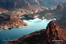


Cruising on Lake Powell and manoeuvring through the canyons is one activity you have to put on your list of "must do" tours. The boat captains are very skilled and well versed in the history, culture and geology of their patch. They also have a great imagination, a wicked sense of humour and an eye for the unique beauty of the area.

Looking up at these great hunks of rock really brings home the fact that we're just tiny specks compared to the vastness of nature. Quite a humbling experience.

Here's more information on Glen Canyon National Recreation Area.

Tuesday, August 2, 2011

Capitol Reef is Captivating, Really


Capitol Reef National Park, one of the Utah parks in the south, really is captivating. It's a long skinny national park accessible between Torrey and Hanksville. Or if you're doing a clockwise trip around the national parks like I did, it's between Bryce Canyon National Park to the west and Canyonlands National Park and Arches National Park to the east.


I love photographing different signs. The national parks, in particular, have a clear welcoming sign that lets you know that you're in for something spectacular. Photographing signs also indicates where the next photographs have been taken. It's also not a bad idea to photograph the sign when you leave a place (for obvious reasons).


The Visitor Center very fittingly blends in well with its surroundings. It's well worth a visit to pick up maps and information, look at the exhibits, watch a short video, buy souvenirs and use the rest rooms. The location is at the junction of the Scenic Drive and Route 24.

I really only had time to travel along the Scenic Drive and back and then continue east along the main road. However, the park really needs a couple of days to explore.

Looking at the photos, you can see that Capitol Reef National Park is one of those really rocky Utah parks. It's comprised of 378 square miles of towering landforms, canyons, mesas and folded rock layers and it's a photographer's Paradise (most of my photos of Utah are rocks, rocks and more rocks!). Stay tuned for more posts later.

Here's more information about Capitol Reef National Park.

Tuesday, July 26, 2011

Hike and Tour Capitol Reef National Park , Utah, Using a Great Guide


To get the most enjoyment out of hiking and touring in Capitol Reef National Park, southern Utah, you need information from someone who really knows the park. Check out this one, Capitol Reef National Park: The Complete Hiking and Touring Guide [Paperback], by Rick Stinchfield.

Click on the ad for more information.


Product Description
The only complete guide to Capitol Reef National Park whether on foot or from the road.

Finally, the total experience of enjoying Capitol Reef National Park has been captured in one comprehensive volume.

About the Author
Rick Stinchfield, and his wife, Lynne, have spent three months in each of the last six years volunteering and living in Capitol Reef National Park. He is the author or co-author of several articles on mineral collecting, as well as publications on recycling and non-motorized commuting. Rick and Lynne life in Pagosa Springs, Colorado.

Sunday, July 10, 2011

Hike the Trails in Arches National Park, Utah, Using a Great Map


To get the most enjoyment out of hiking in Arches National Park, southern Utah, you need a good map. Check out this one, National Geographic TI00000211 Map Of Arches National Park - Utah from National Geographic.

Click on the ad for more information.


Product Description
This map is updated to reflect road closings, new trails, and campground relocation, and includes detailed trail information, points of interest, trailheads, picnic areas, facilities, and more. Included on the map are Arches National Park, The Highlands, Little Valley, Devils Garden, Lost Spring Canyon Wilderness area, Negro Bill Wilderness area, Scott M. Matheson Wetlands Preserve, Cache Valley, Delicate Arch, Broken Arch, Sand Dune Arch, Pine Tree Arch, Private Arch, Dark Angel, Double Arch, and more. The map also includes the Colorado River, the Windows Section, Petrified Dunes, and fascinating information about the parks geology, archaeology, history, and culture. Includes UTM grids for use with your GPS unit. Approximately 4.25in x 9.25in folded and 27in x 39in fully opened.

Saturday, July 2, 2011

Amazing Arches is Absolutely Awesome


Arches National Park, in southern Utah, USA, is absolutely awe inspiring. So much so that the state has actually put an image of Delicate Arch, located in the park, on vehicle number plates. I'm obviously not the only one gobsmacked by this national park!

It's easy to get to being not that far out of Moab, action capital of Utah. Just take US 191 and travel for about 5 miles north of Moab - a national park situated so close to a major town. How good is that?


After you've picked up your information at the Arches Visitor Center, you then head up the winding road to really enter the park.


Obviously there are many arches in the park to give it its name. You may think a dozen or so but you'd be wrong. Apparently there are over 2,000 arches and they vary considerably in size from something a few feet across to the largest, which is Landscape Arch. This one is 306 feet wide and so skinny too!


Check out the Arches National Park website for further information.